Glacial Erosion and Michigan Glacial History
2 Glacier Lesson Plans: Glacial Erosion and Michigan Glacial History
Grade: 3
Standards from the Michigan Department of Education:
E.SE.E.2 Surface Changes- The surface of Earth changes. Some changes are due to slow processes, such as erosion and weathering, and some changes are due to rapid processes, such as landslides, volcanic eruptions, and earthquakes.
E.SE.03.22 Identify and describe natural causes of change in the Earth’s surface (erosion, glaciers, volcanoes, landslides, and earthquakes).
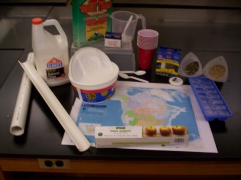
Materials Needed for Both Lessons: Borax Laundry Booster, Measuring Cup, 2 Quart Mixing Bowl, 1 Cup of Glue per student or group (1 gal. jug is ideal), Toothpicks, Spoons for mixing, Warm Water (warm water from any tap will work), Laminated Map of North America, Half Cut PBC Pipe, 10 Cups, Sand, Gravel, Modeling Clay, Timer, and Wax Paper
An In-Depth Look at Glacial Landforms and Michigan's Glacial History (Background Information)
“Over the past 25,000 years glaciers have had an even greater effect on our global landscape than earthquakes, volcanoes, hurricanes, or floods. But because they move so slowly they are often over looked as a significant agent of change” (Newton’s Apple, 1997). A glacier is a large mass of ice that acts like a liquid as it flows under its own weight. Glaciers are born where there is more snow and ice accumulation than there is melting. As more and more snow and ice gather on the surface of the glacier it is compacted down and creates the liquid motion of movement. It is not typical for ice to move, but it is typical for glaciers to do so.
Glaciers reshape the underlying and surrounding landscape as they move, through both erosion and deposition. For glaciers erosion is when the movement of a glacier across a landscape scours the surface, picking up both rock and soil as it traps it all within its ice. A glacier can "carve" a U-shaped valley, wearing away rocks and soil through Abrasion and Plucking thus moving large pieces of rock and debris. Plucking occurs through a process called freeze-thaw where the continual melting and re-freezing of within rock crevasses causes a rock fragment to be disassociated from its original parent rock. The then plucked pieces of rock are carried by the glacier and can cause abrasion when they are scraped across the landscape or rock surface leaving visible Striations and grooves indicating which way the glacier flowed over the area. “As the glacier advances it pushes the earth and rock forward, almost like a conveyor belt, and dumps it to the side along the way or at the end of the glacier (deposition). Depositional features include meltwater deposits, drumlins, eskers, and moraines.” (NSIDC, 2006).
Many depositional landforms are created by Meltwater releasing sediment and moving it away from the glacier. Meltwater plays a vital role in how glaciers move as there is a small layer of melted ice-water at the base of many flowing glaciers. The meltwater can erode away large volumes of sediment just like a normal river system. An Outwash deposit is composed of sediment that is washed out of the glacier by meltwater streams. The size of the particles that are deposited depends on the swiftness of the current. Outwash deposits are typically stratified or layered into different grain sizes, depending upon the current at the time of deposition.
On the other hand, there are Drumlins and Eskers which are small elongate hills and ridges of deposited material oriented in the same direction as the glacial flow. Differences lie with the fact that drumlins are large deposits of clay and rocks that the glaciers plastered into a large drumstick-shaped hill. Eskers are long ridges of deposited material that run parallel to the direction of ice flow. As the meltwater streams flow in tunnels under the ice they carry and deposit sediment into long hilly patterns that we can identify as eskers.
Another really important landform left by glaciers are Kettles. These are formed by large chunks of ice that break off from the glacier and are subsequently buried by sediment. Eventually the ice chunks melt, leaving a depression that is approximately the size of the original ice chunk. When filled with water these kettles are called Kettle Lakes. Kettle lakes are found all over the Michigan landscape. In fact a majority of inland lakes are considered to be kettle lakes.
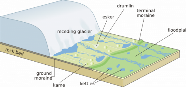
Figure 1: List of the various glacial deposits left by a receding glacier (retreating glacier) to accompany the description of the landforms above. Source: http://upload.wikimedia.org/wikipedia/commons/thumb/d/da/Receding_glacier-en.svg/800px-Receding_glacier-en.svg.png
The glacial ice that advanced and retreated over Michigan originated in the Hudson Bay region. The advances and retreats were caused by temperature changes over long periods and show how the temperatures can affect the dynamic equilibrium of glaciers. It is at the dynamic equilibrium that the glaciers will find a balance between the melting at the front of the glacier to the consistent flow rate of the back portion of the glacier. To and observer, it may look as if the glacier has either stopped flowing or has begun to flow in the opposite direction, but these two theories are incorrect. Scientist have placed poles within glaciers and seen how they bend down hill within the glacier even when it is receding back up hill, that is how we have been able to look at flow as a continuous motion- in the same direction. A glacier "retreat" occurs when the amount of melting of snow and ice is greater than the amount of new snow and ice being added to the glacier. The stop or retreat of these glaciers will leave large piles of glacially derived sediment behind and begin to build up at the foot of the glacier. These depositional landforms are called End Moraines as well as Terminal Moraines.
About 18,000 years ago Michigan as well as most of Canada and the Victoria islands had accumulated enough snow and ice to create a large glacier system to cover these areas. Over the next eight thousand years through several glacial advances and retreats, the glacier eroded and deepened the Great Lake basins. The large-scale erosion moved sediment from Canada through the Great Lake basins and deposited it all over the lower Michigan, Ohio, Wisconsin, and Indiana. The type of sediment deposited is often referred to as glacial till. Glacial till is what the glacier deposits after melting or when it is expelled through the base, front, or sides of the glacier. Till usually varies in its grain size, for example, a glacial till will have large clasts (boulders, rocks, pebbles) as well as sand mixed together verses a beach sediment deposits where the primary grain size is sand.
A common misconception is that the Great Lakes were formed by large chucks of ice falling off of the glacier and leaving kettle lakes, but that is far from the truth. The lake basins are underlain by weak rocks that were carved out by glacial freeze-thaw (erosion agent) and scouring. Shale and sandstone are the two typical rock types that the glaciers found easy to break apart and move during its advances and retreats. If we were to use a rock hammer to break these two rock types apart we would find the task easy with the shale and sandstone. In contrast if we tried to break a granite rock, we would find it difficult, as granite has an interlocking crystal structure which makes it a much stronger rock.
So, for the glaciers found it much easier to carve out of the shale and sandstone than the crystalline rocks that make up Michigan’s bedrock and land today. From the glaciers scouring out the softer sediment and rock it left large basins in which the groundwater was able to connect with the open areas to form the lakes that we now represent as the HOMES acronym- Huron, Ontario, Michigan, Erie, and Superior.
Following Table Adapted from Farrand, 1988
| major_stages_of_in_evolution_of_great_lakes.doc | |
| File Size: | 95 kb |
| File Type: | doc |
Above Map Show Where Glacial Accumulation Started: Hudson Bay
Developmental Relevance to Third Graders
Glaciers are not often discussed in many elementary classrooms. Reasons could include the thought that they are not as instantaneous and therefore amusing as volcanos or earthquakes, which usually fill the topic of changes on the Earth's surface in third grade classrooms. However, third graders or eight year olds are fastenated with learning and mastering new ideas and concepts. Framing the sudy of glaciers as an opportunity to learn about one of the largest landscape changers is motivating and engagin to children of this age.
Eight year olds have a lot of energy with great enthusiasm but they also have little focus and direction which makes it difficult for them to appropriately use their two best attributes. These third graders will need help cutting down their enthusiastic appetite into "bite size" proportions. Wood (2007) says that this included giving them small homework assignments which should be on longer than a half-hour and should be limited in scope and expectations. This has been defined as "incremental successes," as the students receive multiple short lessons they feel like they can master the material which in turn motivates and engages them in the next short lesson.
As for these lesson plans, they are long but can be easily broken up into much smaller lessons over the course of several days. For personal classroom reasons I had made them both the length of an hour, but it is not necessary to use them the same way that I used them. I will note that students of the third grade may make note that they are "bored" or "it's too hard," this is very typical and means that the students just need to be redirected (Wood, 2007). So, I strongly encourage that you read the background information before teaching any of the lessons in order to help redirect the students.
Reference:
Wood, C. (2007) Yardsticks: children in the classroom ages 4-14. 3rd Ed. Northeast Foundation for Children.
Turners Falls, MA.
Important to note: Both of these lessons are packed with information that should be broken up into several lesson. I would suggest dividing up the lessons so that they fit your students' needs.
Lesson Plan for Glacial Landforms
| lesson_plan_for_glacial_landforms_and_erosion.dox.docx | |
| File Size: | 1099 kb |
| File Type: | docx |
| lesson_plan_for_glacial_landforms--_pictures.docx | |
| File Size: | 1676 kb |
| File Type: | docx |
Lesson Plan for Michigan Glacial History
| lesson_plan_for_michigan_glacial_history.docx | |
| File Size: | 738 kb |
| File Type: | docx |
Gak Glacial Activity
To watch a demonstration of how the gak glacial activity works visit the following youtube website:
http://www.youtube.com/watch?v=J1ZEGUg5suc
Resources
Books and articles
Farrand, W. R. (1988). Glacial Lakes around Michigan. Geological Survey Division, Michigan Department of Environmental Quality, Bulletin 4.
Hambrey, M. (1992). Glaciers.New York: Cambridge University Press.
Hostetler, S. (1997, Jan). Near to the edge of an ice sheet.Nature, p. 393Ð394.
Kimber, R. (1993, May). The glacier's gift.Audubon, pp. 52Ð53.
Lee, L. (1994, June). Summer's here: Chill out! National Geographic World, pp. 10Ð14.
Pfeiffenberger, J. (1997, April).Ice age journey.Earth, pp. 76Ð79.
Walker, S. (1990).Glaciers: Ice on the move.Minneapolis: Carolrhoda Books.
Organizations
The World Glacier Monitoring Service. Wilfried Haeberli and Martin Hoelzle,
Department of Geography.
University of Zurich
Winterthurerstrasse 190CH-8057
Zurich, Switzerland
www.nercbas.ac.uk/public/icd/icsi/ WGMS.html
Web sites
42 Explore. Topic: Glaciers, links for exploring glaciers. Retrieved April 22, 2009 from http://42explore.com/glaciers.htm
**Great website for all your needs on searching glacial landforms, activities, as well as background knowledge.
Alaska SAR Facility-Great Glacial Images 168.99.215.253/earth/glacier.html
Athropolis Links. Glacier Links for Kids. Retrieved April 22, 2009 from http://www.athropolis.com/links/glacier.htm
Damery, D. (2004). Formation of the Great Lakes.
Retrieved March 12, 2009 from http://www.emporia.edu/earthsci/student/damery1/gl_form.html
National Snow and Ice Data Center (NSIDC). (2006). Educational Center: All about Glaciers.
Retrieved April 19, 2009 from http://nsidc.org/glaciers/story/move.html
Newton’s Apple & 3M. (1997). Glacier Climbing: What is a Glacier and how does one move? Retrieved March 10, 2009 from http://www.reachoutmichigan.org/funexperiments/agesubject/lessons/newton/glaciers.html
USGS Cascades Volcano Observatory vulcan.wr.usgs.gov/Glossary/Glaciers/ framework.html
